
El Niño and La Niña Made Simple: The Pacific Engine and India’s Monsoon
Understand neutral conditions, El Niño and La Niña with labelled Pacific cross-sections.
Learn trade winds, upwelling and the thermocline in plain language.
See why India’s monsoon can be affected—and why the outcome is never automatic.
📌 Revision Pointers
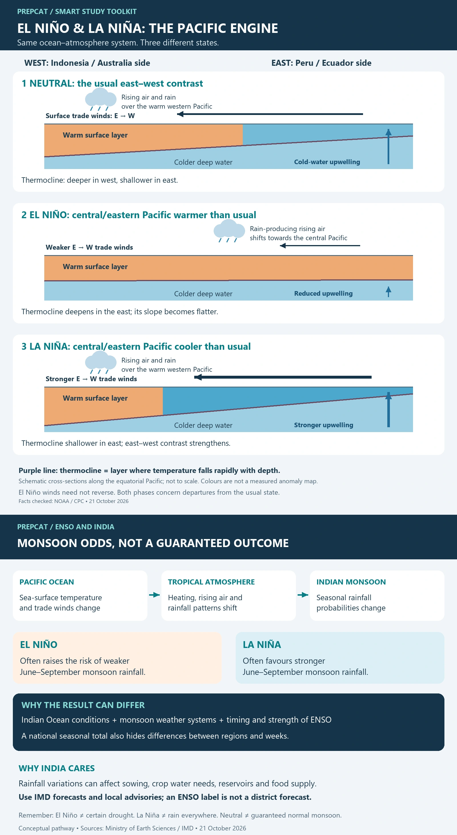
ENSO: linked Pacific ocean and atmosphere; neutral, warm and cool phases.
Neutral: E → W trade winds; warm west, cooler east; eastern upwelling.
El Niño: weaker trades; central/eastern Pacific warmer than usual; reduced eastern upwelling.
La Niña: stronger trades; central/eastern Pacific cooler than usual; stronger eastern upwelling.
India: El Niño often weakens and La Niña often supports southwest monsoon rainfall; neither guarantees the result.
Read the model: west is left, east is right; these are mechanisms, not current forecasts.
1. Start Here: ENSO Is a Pacific Ocean–Atmosphere Pattern
ENSO means El Niño–Southern Oscillation. It links sea-surface temperatures in the tropical Pacific with winds, air pressure and rainfall. Its three broad states are neutral, El Niño and La Niña. They are not a fixed annual sequence.
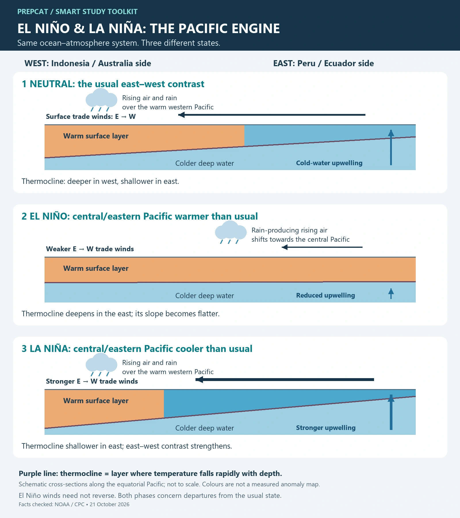
In the diagrams, west is on the left (Indonesia/Australia side) and east is on the right (Peru/Ecuador side). “Warmer” or “cooler than usual” means a departure from the normal conditions for that place and season.
Open Diagram 1: neutral, El Niño and La Niña side by side · Open Diagram 2: why India’s monsoon can be affected.
2. Neutral: Winds Push Warm Surface Water West
The usual trade winds blow from east to west along the equatorial Pacific. They help pile warm surface water towards the western Pacific. In the east, upwelling brings colder water upwards to replace water moved away near the surface.
Warm western-Pacific waters favour rising moist air and rain. The associated east–west atmospheric circulation is called the Walker circulation. The thermocline—a layer where temperature falls rapidly with depth—is usually deeper in the west and shallower in the east.
3. El Niño: The Usual Push Weakens
During El Niño, the trade winds weaken and the central and eastern equatorial Pacific become warmer than usual. Warm water extends farther east, the eastern thermocline deepens and cold-water upwelling is reduced. Rain-producing rising air shifts eastwards, towards the central Pacific.
Think weaker westward push → more warmth in the central/eastern Pacific → a changed pattern of rising air and rain. The ocean and atmosphere reinforce one another; this is a coupled process, not just one current changing direction. The winds do not have to reverse in every event.
4. La Niña: The Usual Contrast Strengthens
During La Niña, the trade winds are stronger than usual. More warm surface water is pushed west, eastern upwelling strengthens, and the central and eastern equatorial Pacific become cooler than usual. The eastern thermocline is shallower, and the usual east–west contrast and Walker circulation generally strengthen.
Memory hook: El Niño = weaker trades + warmer central/eastern Pacific. La Niña = stronger trades + cooler central/eastern Pacific. “Cool phase” does not mean that the entire Pacific, or all of India, becomes cold.
5. How Can a Pacific Pattern Affect India?
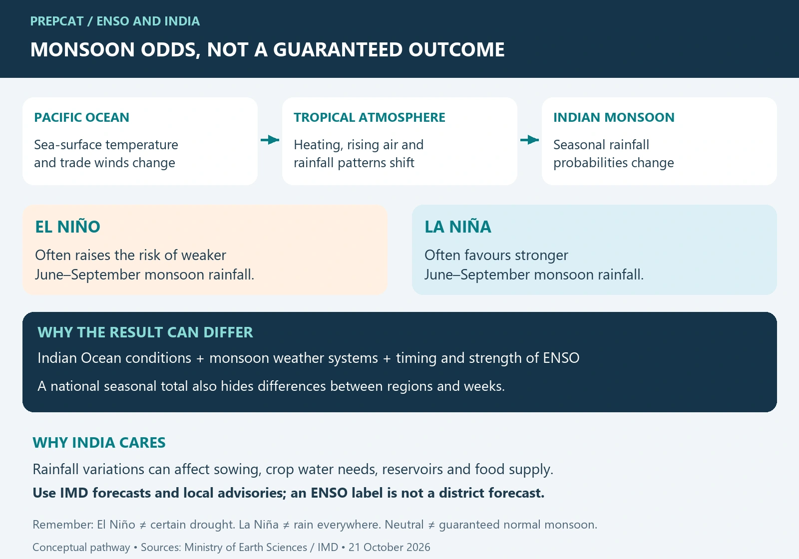
Changes in tropical ocean heating alter atmospheric circulation and rainfall far beyond the Pacific. These distant influences are called teleconnections.
El Niño: often associated with weaker Indian southwest monsoon rainfall and a greater risk of rainfall shortfall.
La Niña: often favours stronger Indian southwest monsoon rainfall.
Neither is a guarantee: the Indian Ocean, monsoon weather systems, and the timing and strength of the event also matter. Seasonal totals can hide regional drought or episodes of heavy rain.
This comparison mainly concerns the June–September southwest monsoon; do not apply it mechanically to every Indian season. As a useful counterexample, IMD’s historical table shows that India’s all-India seasonal rainfall in the strong El Niño year 1997 was close to its long-period average.
Relevance: rainfall variations can affect sowing decisions, rain-fed crops, irrigation demand, reservoir storage and food supply. ENSO is a risk signal for planning, not a forecast for a particular farm or district. Use IMD forecasts and local advisories for actual conditions.
6. Three Confusions to Avoid
ENSO is not the Indian monsoon: it is one influence on the monsoon.
El Niño is not global warming: ENSO is natural climate variability, operating alongside a changing background climate.
A coloured diagram is not a forecast: these are simplified mechanisms, not maps of current sea temperatures or expected Indian rainfall.
7. Quick Self-Check
Q1. Trade winds strengthen and the central/eastern equatorial Pacific cools relative to usual conditions. Which phase? Answer: La Niña.
Q2. Does an El Niño declaration prove that every Indian region will have drought? Answer: No. It changes the odds; other influences and local weather still matter.
Q3. Why can El Niño reduce eastern-Pacific upwelling? Answer: weaker trade winds and a deeper eastern thermocline make cold water less readily supplied to the surface.
Sources
NOAA: ENSO basics; NOAA: ocean–atmosphere coupling; NOAA: three Pacific states; CPC: El Niño thermocline; CPC: La Niña thermocline; Ministry of Earth Sciences: India’s monsoon relationship; IMD: historical rainfall in El Niño years.
💭 Conclusion
Follow the chain: trade winds redistribute Pacific surface warmth; ocean conditions and atmospheric circulation adjust together; rainfall patterns change. For India, use ENSO to understand monsoon risk while keeping regional weather and other climate influences in view.